Gen Misc
For all items that do not fit elsewhere // Area sort for Data Dump
Naturalizations
California, Northern U.S. District Court Naturalization Index, 1852-1989
| Name | Residence | Date of Birth | Date of order of admission | Petition No | Alien Reg No |
| Skuse, Grantley Thomas | 1238 Turk St, San Francisco, California | Aug 1, 1889 | Nov 11, 1954 | 112433 | 5 736 779 |
| Skuse, Jeanne | 1238 Turk St, San Francisco, California | Jul 6, 1895 | Nov 11, 1954 | 110228 | 6 995 193 |
California, Southern District Court (Central) Naturalization Index, 1915-1976
1915-1930 (Schm-Shel are missing from index)| Name | Date | Vol - Page | Petition No |
| Edmond Elsworth Skuce | Sept 6, 1940 | 410 - 98 | 78928 |
| Mayme Elizabeth Skuce | Apr 5, 1940 | 398 - 211 | 73541 |
| Name | Residence | Age | Date Cert issued | Court | Petition No |
| Edmond Elsworth Skuce | 1706 W 48th St, Los Angeles, California | 52 | Dec 13 1940 | Los Angeles | 78928 |
| Mayme Elizabeth Skuce | 1706 W 48th St, Los Angeles, California | 51 | May 10, 1940 | Los Angeles | 73541 |
Illinois, Northern District Naturalization Index, 1840-1950
| Name | Address | Date | County of Birth or Allegiance | Cert No | Microfilm | Notes |
| Peter Skuce | Ottawa, LaSalle Co, Illinois |
April 6, 1874 |
Great Britain & Ireland |
Book H Page 331 |
M1285-152 / LDS 1432152 | Soundex S200 |
United States, New England Naturalization Index, 1791-1906
| Name | Address | Location of Court | Date | County of Birth or Allegiance | Cert No | Microfilm | Notes |
| John Skuse | Franklin, Mass | USCC Boston | 21 Sept 1880 | 20 Nov 1855, Ireland | 127-155 | M1299-106 / LDS 1429776 |
Soundex S200 |
| Edward Skuice | Windsor, Conn | Superior, Hartford | 18 Mar 1863 | Great Britain | M1299-32 / LDS 1429702 | Soundex S200 |
Index to Declarations of Intention, Volume 1 (1866-1895); Allegany Co., New York
Skuce, John. Ireland NY-Allegany-NYSC-DOI 1-238
New York, County Naturalization Records, 1792-1976
| Name | Address | Certificate | Location of Court | Country of Birth/Allegiance | DoB | Date and port of arrival | Date of natrualization | Notes |
| Joseph Skuce | Westons Mills, NY | V-15-P26-2180713 | Supreme, Cattaraugus Co, NY | Great Britain | Aug 17, 1901 | Sept 9, 1920, New York | March 1, 1926 | |
| Martha Jane | Westons Mills, NY | V-15-P26-2180712 | Supreme, Cattaraugus Co, NY | Great Britain | Apr 21, 1898 | Sept 9, 1920, New York | March 1, 1926 | |
| William Daniel Skuce | Westons Mills, NY | V15-P43-2180748 | Supreme, Cattaraugus Co, NY | Great Britain | Sept 27, 1895 | Sept 9, 1920 | Sept 7, 1926 | Wit: Mrs Frank Skuse, Weston Mills |
| John Skuse | V-4 P-233 | County, Cattaraugus Co, NY | Great Britain | Oct 27, 1870 | ||||
| Frank Skuse | V-5 P54 | County, Cattaraugus Co, NY | Great Britain | Oct 16, 1891 |
New York City Naturalization Index 1891-1948
| Certificate Number | Surname | First Name | Age | Petition Volume | Petition Number | Date of Certificate | Approx year of Birth | District |
| Skuse | Richard | 27 | 158659 | 11/11/1929 | 1902 | Southern | ||
| Skeuse | Agnes | 54 | 299467 | 02/14/1938 | 1884 | Southern | ||
| Skeuse | Frances | 50 | 299466 | 02/14/1938 | 1888 | Southern | ||
| Skewes | Annie B | 487 | 150313 | 1930 | Eastern | |||
| Skewes | Sidney H | 487 | 150314 | 1930 | Eastern |
Naturlization: NY-ALLEGANY-NYSC-DOI (Vol 1) 1866-95
Skuce, John - from Ireland - vol 1 p238
Naturlization: NY-ALLEGANY-NYSC-DOI (Vol 15) 1825-29
Skuce. Joseph - from Ireland - vol 15 p26
Skuce, Martha Jane - from Ireland - vol 15 p25
Skuce, William Daniel - from Ireland - vol 15
p43
New York South District Index to Petitions for Naturalization, 1824-1941
Source: LDS
Richard Skuse
Anges Skeuse
Frances Skeuse
NY Southern, Naturalization
1927, James Skuse, of Ireland
1929, Richard Skuse, of Ireland
New York, Southern District Index to Petitions for Naturalization, 1917-1950
| Name | Reference | Notes |
| Richard Skuse | 158659 | M1676-54 |
| Agnes Skeuse | 299467 | M1676-96 |
| Frances Skeuse | 299466 | M1676-96 |
New York, Southern District Index to Petitions for Naturalization, 1824-1941
| Name | Date | Reference | Notes |
| Richard Skuse | 235348-402 | M1675-77 | |
| Agnes Skeuse | Aug 27, 1935 | 366767 | M1675-77 |
| Frances Skeuse | Aug 27, 1935 | 366766 | M1675-77 |
New York City Courts, Naturalization, 1792-1906
| Name | Year | Witness | Notes |
| James Skuse | 1847 | ||
| Thos H Skuce | 1855 | ||
| Thomas Skeusce | 1866, Feb 10 | ||
| William Skuse | 1888 | ||
| Herman Nusbaum | 1875 | James R Skuse | |
| John P Kopf | 1858 | Thomas H Skuse | |
| John Santry | 1860 | James Skuse | |
| Thomas Bennett | 1872 | James Skuse | |
| John Joseph Oehl | 1867 | Thomas W Skuse | |
| Daniel Hegarty | 1860 | James Skuse | |
| James E Johnson | 1866 | Thomas W Skuse | |
| Jeremiah T Johnson | 1866 | Thomas W Skuse | |
| Andrew Brown | 1875 | James R Skuse | |
| John Buhler | 1867 | Charles A Skew | |
Pennsylvania, Eastern District Naturalization
Harland Laverne Skuce, age 45. Admission 14 Apr 1943 at Philadelpiha, Pa. Petition No 168480. Residing 814 W Venango st, Phila, Pa.
Washington State, Petition for Naturalization 1909-1954
| Name | DoB | PoB | Where emigrated | Port of Entry | Date | Where Naturalized | Date of Naturalization | Spouse | Children | Reference | Notes |
| William Henry Skuce | 2 Dec 1896 | Skibbereen, Co Cork, Ireland | Calgary, Canada | Eastport | 24 Feb 1924 | Clark Co | 14 Apr 1939 | Fern Lenore | Patricia Fay, Betty Jean, Billie Gail | Vol 12/14, No 1099 |
Misc
Ireland Place Names or IreAtlas or Irish Times
Common locations for Skuce/Skuse place names in Ireland
| Placename | County | Acres | Place_Typee | Barony | Civil_Parish | Poor_Law_Union |
|---|---|---|---|---|---|---|
| Derrynafulla | Cork, W.R. | 768 | Townland | Bear | Kilcaskan | Bantry |
| Glengarrif | Cork, W.R. | 74 | Townland | Bear | Kilcaskan | Bantry |
| Ardyhoolihane | Cork, W.R. | 85 | Townland | Bantry | Kilmocomoge | Bantry |
| Dromleigh North | Cork, W.R. | 102 | Townland | Bantry | Kilmocomoge | Bantry |
| Dromleigh South | Cork, W.R. | 399 | Townland | Bantry | Kilmocomoge | Bantry |
| Kilnaruane | Cork, W.R. | 20 | Townland | Bantry | Kilmocomoge | Bantry |
| Clashadoo | Cork, W.R. | 746 | Townland | Carbery West (W.D.) | Durrus | Bantry |
| Dromreagh | Cork, W.R. | 841 | Townland | Carbery West (W.D.) | Durrus | Bantry |
| Coolcoulaghta | Cork, W.R. | 1145 | Townland | Carbery West (W.D.) | Durrus | Bantry |
| Foilnamuck | Cork, W.R. | 378 | Townland | Carbery West (W.D.) | Skull | Skull |
| Coosane | Cork, W.R. | 270 | Townland | Carbery West (W.D.) | Skull | Skull |
| Inishbeg | Cork, W.R. | 370 | Townland | Carbery West (E.D.) | Aghadown | Skibbereen |
| Derrygereen | Cork, W.R. | 293 | Townland | Carbery West (E.D.) | Creagh | Skibbereen |
| Skibbereen T. | Cork, W.R. | xx | Town | Carbery West (E.D.) | Creagh | Skibbereen |
| Skibbereen T. | Cork, W.R. | xx | Town | Carbery West (E.D.) | Abbeystrowry | Skibbereen |
| Baurnahulla *1 | Cork, W.R. | 746 | Townland | Carbery West (E.D.) | Dromdaleague | Skibbereen |
| Lahanaght | Cork, W.R. | 971 | Townland | Carbery West (E.D.) | Drinagh | Skibbereen |
| Skahanagh | Cork, W.R. | 173 | Townland | Carbery West (E.D.) | Myross | Skibbereen |
| Castlehaven | Cork, W.R. | 202 | Townland | Carbery West (E.D.) | Castlehaven | Skibbereen |
| Ballylangley | Cork, W.R. | 288 | Townland | Carbery West (E.D.) | Ballymodan | Bandon |
| Kilbrogan | Cork, W.R. | 371 | Townland | Kinalmeaky | Kilbrogan | Bandon |
| Knocknastooka *1 | Cork, W.R. | 118 | Townland | Carbery West (E.D.) | Desertserges | Bandon |
General Alphabetical Index to the Townlands & Towns, Parishes & Baronies of Ireland. 1851
(Cannot find the location of the source I used)
| No of Sheet | Area if Acres | County | Barony | Parish | Poor law union in 1857 | Townland Census of 1851, Part I | ||||
| A | R | P | Vol | Page | ||||||
| 104 | Derrynafulla | 768 | 1 | 26 | Cork W/R | Bear | Kilcaskan | Bantry | II | 120 |
Bandon Electors 1832
Persons who voted for Hon W.S. Bernard, Second Day
Skuse, Chrles South Main St Shopkeeper
Ballymodan Tithe Applotements - 1832
SCUSE William - Ballylangley, Cloughmacsimon, Currivridig
Tithe Applotments for Co Cork
CorkGen or National Archives
Dromdaleague, 1826
Butler's Gift,
Nathaniel Skuce & partners, 95 acres
Drimolague, Nathaniel Skuce, 30 acres
(*can be transcribed as Slevin/Skince)
Drinagh, 1833
Lahinaght, Nathaniel Skuce, 40 acres
Myross, 1829
Skannagh, John Skuse & Co, 6 acres
Skull, 1827
Lisacaha, Daniel Gallaher, Charles Skuice & James Bennett, 69 acres
(*can be transcribed as Skuce)
Ballymodan, 1832
Ballylangley, William Scuse, 7 acres
Ballylangley, William Scuse, 16 acres
Cloghmacsimon, William Scuse, 10 acres
Currivridig, William Scuse, 3.2 acres
Durrus, 1830
Droumreagh, John Skuce, 10.12.14 acres
(*Can be transcribed as Skee)
Kilcaskan, 1827 (Kerry)
Dirrinifolla,Mrs Scuce, 8 acres (Mrs Scuse (Widow)
(*can be transcribed as Sence)
Kilcaskan, 1828 (Cork)
Dirrinifolla, Mrs Scuce, 8 acres
(*can be transcribed as Sence)
Kilmeen, 1834
Lamanagh, Margaret Skuce, 47.4.92 acres
(*Can be transcribed as Shuce)
Castlehaven Vestry Book, Skibbereen, Ireland, 1739-1824
Skeuse, Catherine, Widdow, List of Poor 1738/9
Skeuse, Elizabeth, alias Kingston, Widdow [and] her son, List of Poor 1738/9
Skeuse, Paul; (Myross) A dau. Of Paul Skeuse, Jane (My)..br 30 1740, Fragment of Parish Register
Skeuse, Ricd. Jun. app. Church Warden 4. Vestry Meeting 30 March 1741
Skeuse, Richd., Church Warden X 5. Vestry Meeting 10 April 1742
Skeuse, Peter 12. Vestry Meeting, 31 March 1746
Skews, Katherine, List of Poor 23 April 1753
Skuse, Widow List of Poor 23 March 1761
Skuse, Thomas, app. Church Warden 54. VM 2 April 1771
Skuse, Thomas 55. Vestry Meeting 21 April 1772
Skuse, Thomas 56. Vestry Meeting 13 April 1773
BANDON HISTORICAL JOURNALS- ISSUE 13 1997
Bandon Grammar School 1937 (photograph), page 14
SKUSE Henry, page 14
BANDON HISTORICAL JOURNALS- ISSUE 15 1999
Bandon Grammar School. 1935: The whole school photograph 34,35
SKUSE Henry, page 34
LDS 6343062 County Cork West. Originals
(Maps/Breakdown of Townlands in a Parish, as listed by County)
<Introductory Page>
Townland Maps
The townland is the smallest and most ancient of Irish land divisions, and is the goal of all family researchers in identifying the origin of their ancestors. The townland was names at an early period and they usually referred to a very identifiable landmark in the local area such as a mountan, a bog, an oak forest, a village, a fort or a church. The townland became standardized as a basic division in the 17th century surveys by people with little knowledge of the Irish language. As a consequence many place anmes were either lost or had their meaning or construction altered.
A record of townland names, shapes and sizes for all Ireland exist in the maps of the Ordnance Survey completed in 1846 at the scale of 6 inches to 1 mile. The complete set of maps can be consulted in the National Library, Dublin. On these maps are now record the standardized spellings of Ireland’s 60, 462 townlands.
On a county basis, however, it is not practical to consult the 6” Ordnance Survey maps and, because of their large scale, they can not show, at a glance, parish boundaries. For example it takes 110 maps to cover County Donegal at a scale of 6inches to 1 mile.
It is the intention of this eries of maps to show, on a county basis, all townlands within their respective civil parishes. To 1898 the civil parish was the major administrative division. The two great surveys of the 19th century 0 the tithe assessment and the Griffith’s valuation – were compiled on a civil parish basis with householders listed against their appropriate townland address.
The purpose of the maps reproduced here is two fold:
- to provide the means to locate an ancestral home, to show all townlands and their relationship to one another.
- to act as a reference tool to those researching Irish record sources, in particular, tithe records, the Griffiths valuation and 19th century census returns.
The General Alphabetical Index to the Townlands of Ireland, based on the 1851 census, was used to compile the parish boundaries.
How to use these maps
Use the index t the beginning of each county to identify the parish you require. In addition to the depiction of each civil parish’s townlands there is, alongside each map, an alphabetical list of each parish’s constituent townlands.
The townland spellings on our maps are those recognized by the Ordnance Survey from the 1830’s onwards. This means townland spellings in records collected before this time, such as the tithe books, are very varied. For example in Glendermot Parish, County Londonderry the same townland appears as Coolkeerragh in the Griffiths valuation, as Killkeraugh in the 1831 census and as Culkeeragh in the tithe book. The maps and accompanying lists will help in deciphering early spellings of townland names.
These maps were compiled by the trainees of Derry Youth and community Workshop and by the employees of the Inner City trust. Both organizations are funed by the Department of Economic Development.
Brian Mitchell, Inner City Trust, 10 Bishop Street, Londonderry, N. Ireland. January 1989.
<Page, Map of Ireland>
<Page, Map of Cork West>
<Page iv>
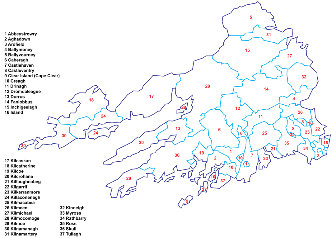
Cork West Index
Parish Page
1 Abbeystrowry 1
2 Aghadown 3
3 Ardfield 5
4 Ballymoney 7
5 Ballyvourney 9
6 Caheragh 12
7 Castlehaven 15
8 Castleventry 17
9 Clear Island (Cape Clear) 19
10 Creagh 21
11 Drinagh 24
12 Dromdaleague 26
13 Durrus 29
14 Fanlobbus 31
15 Inchigeelagh 34
16 Island 37
17 Kilcaskan 39
18 Kilcatherine 43
19 Kilcoe 45
20 Kilcrohane 47
21 Kilfaughnabeg 50
22 Kilgarrif 52
23 Kilkerranmore 54
24 Killaconenagh 56
25 Kilmacabea 60
26 Kilmeen 63
27 Kilmichael 65
28 Kilmocomoge 68
29 Kilmoe 73
30 Kilnamanagh 76
31 Kilnamartery 78
32 Kinneigh 81
33 Myross 83
34 Rathbarry 85
35 Ross 87
36 Skull 90
37 Tullagh 95
Page 39
17 Kilcaskan Parish (94 Subdivisions)
(Map) Good Quality, having problems copying (will try taking picture and then put through image editor)
Page 40
1 Adrigle
2 Ballynahown
3 Ballynakilla
4 Bawn
5 Bocarnagh
6 Canrooska
7 Cappaleigh North
8 Cappaleigh South
9 Cappanaparka East
10 Cappanaparka West
11 Cappyaugna
12 Carraduff
13 Carrigrour
14 Cashanavoe
15 Clashduff
16 Clydagh
17 Coolbragh
18 Coomarkane
19 Coongira
20 Coonane
21 Coorannel
22 Crooha East
23 Crooha Middle
24 Crooha West
25 Crossterry East
26 Crossterry West
27 Curragh East
28 Curragh West
29 Currakeal
30 Cyrrakillane
31 Derreenacarrin
32 Derreenagarig
33 Derreenathirigy
34 Derrenavroonig
35 Derreenboy Lower
36 Derreenboy upper
37 <Not listed, missing from page 40/41, check map>
Page 41
38 Derreenagough
39 Derreen Upper
39 Derreny
41 Derryconnery
42 Derrylough
43 Derrynafulla
44 Dorrus
45 Dromagonlane
46 Dromateebara
47 Dronderadown
48 Drondour
49 Drongarvan
50 Drumaclarig
51 Drumlave
52 Esknanucky
53 Faha East
54 Faha West
55 Furkeal
56 Garinish
57 Glengarriff
58 Glenlough
59 Gortore Lower
60 Gortroe Upper
61 Inchintaggart
62 Inchintaglin
63 Kealagonlane
64 Keeltrasna
65 Kilcaskan
66 Kildronmalive
67 Killenough
68 Lackavane
69 Leahill
70 Leitrin Beg
71 Leitrim More
72 Lickeen East
73 Lickeen West
Page 42
74 Loughavaul
75 Lyre
76 Monteen Sudder
77 Muccuragh
78 Reen
79 Reenabulliga
80 Reenneen East
81 Reeneen West
82 Rossnagreena
83 Rossnashunoge
84 Roosk
85 Roughak
86 Shrone
87 Sheeil
88 Teacashel
89 Trafrask East
90 Trafrask West
91 Toureen
92 Toureenageena
93 Ulusker
94 Youngfield